
"We really utilized Site Scan for the metrics. Coming from someone who is an artistic photographer and now I can get data from drone flights, that's the unsung hero of what Site Scan does."
Justin Dorsey, OCMI

Founded in 1897, San Diego State University (SDSU) is the oldest higher education institution in San Diego, California, and is nationally recognized for academic excellence with a ranking of 65 among public universities in the nation. The more than 35,000 students who attend enjoy a comprehensive education along with student clubs and organizations, study abroad initiatives, veterans' programs, and a dynamic Division I athletics program.
Football is among the sports offered, and the San Diego State Aztecs play for fans at Snapdragon Stadium, known during its planning and early construction phases as Aztec Stadium. Previously called Jack Murphy Stadium, Snapdragon Stadium is a new 35,000-seat outdoor college arena for football games and other public events. The construction of the stadium presented an opportunity for sustainable building, and stakeholders wanted to reuse specific materials for the new site.
OCMI, Inc., is a California-based firm that provides estimating, scheduling, and project management (PM) and construction management (CM) services to clients and oversees capital projects at the university. The firm needed a solution to help track the movement of materials at the stadium and provide progress reports to stakeholders. This led OCMI to use drones to fly to the project site and Site Scan for ArcGIS to collect, process, and analyze the imagery, enhancing project visibility and delivering key metrics to stakeholders.
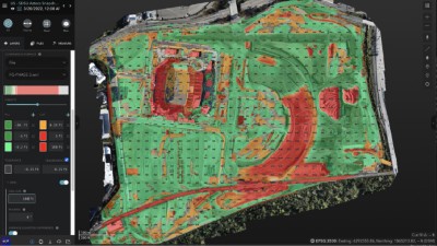 Cut/fill analysis comparing current grade to final design.
Challenge
OCMI, Inc, a project management (PM) and construction management (CM) firm, needed a solution to help track the movement of materials at the Snapdragon Stadium construction site in San Diego and provide progress reports to stakeholders.
Solution
Site Scan for ArcGIS
Result
The use of Site Scan for ArcGIS enabled OCMI to obtain the metrics they needed for their client, create models, and provide stakeholders with up-to-date images for increased visibility.
As part of a large sustainability effort, the construction of Snapdragon Stadium involved recycling all the concrete from Jack Murphy Stadium for use on the new building site. This would essentially require a million cubic yards of materials to be moved. According to Justin Dorsey, project executive and preconstruction manager for OCMI, his team needed a tool to deliver metrics to help better understand this part of the building process.
"We needed a way to track and understand how those materials were being moved in conjunction with the schedule and be able to validate what [contractors] were giving us," says Dorsey.
In addition, the OCMI team also wanted to track the progress of ongoing construction. Jim Cleaton, the director of construction at San Diego State University, who is a client of OCMI, was aware that Dorsey utilized drone technology and asked him to find a tool to provide progress documentation as well as metrics.
As a high-profile project for the community and part of a larger multimillion-dollar construction project, Dorsey was determined to get the right technology to do the best job possible.
"Jack Murphy [Stadium] was a relic to San Diego residents, so that was quite a big deal that the stadium where so many memories were made was going away for the city. So knowing the gravity of that project . . . we had to knock it out of the park for the community," says Dorsey.
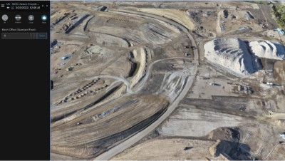 3D Mesh of earthworks.
Dorsey began his search for drone software by interviewing various firms and looking at their software and hardware. He ultimately decided on Site Scan for ArcGIS, which is cloud-based, drone mapping software that's designed for imagery data collection, processing, and analysis. Dorsey says he found Site Scan to be the best choice for several reasons, including the tools that came with it and its scalability.
"Site Scan fit the bill for what we were looking for, and it gave me the flexibility to scale. My goal is not for me only to fly but for me to grow it as a business line within my organization and run it from the enterprise level," explains Dorsey.
Another benefit was that Site Scan was "drone-agnostic," Dorsey adds. Other solutions he looked at required a user to purchase the drone along with ground control points and other proprietary hardware, which would lock them into only using the company's products. Site Scan, on the other hand, provides the option to use different technology. Recently, when one of his organization's drones required maintenance, Dorsey was able to continue flying weekly missions with his personal drone.
Finally, Dorsey learned how to use Site Scan quickly because it was user-friendly, intuitive, and easy to learn. After receiving airspace authorization to fly, Dorsey began flying his drone every Thursday to take shots and view the project site.
"I went out, and I took my drone out and flew it, and I tried to reverse engineer how I thought the software would work," says Dorsey. "The datasets were pretty large, about 700 to 900 photos per mission."
For the stadium construction project, which began in 2020, Dorsey says his typical workflow is to fly the site with a drone, upload the images, then process the imagery. He shares a weekly distribution report with stakeholders that shows the site plan and includes a link to a 2D orthomosaic and a 3D mesh model that lets users remotely walk around the site. Dorsey also includes videos of the site.
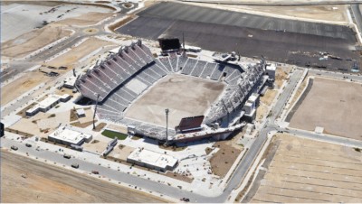 3D mesh of Snapdragon stadium shortly before completion.
According to Dorsey, the OCMI team has been able to use Site Scan to get valuable information on the stadium construction project. Site Scan enables him to provide stakeholders with up-to-date images for increased visibility, even remotely. This was particularly handy because the project began during the COVID-19 pandemic, and people were unable to visit the site in person.
"I get requests from clients [that say], 'Hey, can I get that new plan? Was last Friday the latest capture?' So it's created a sense of awareness of a project site from a visual aspect," says Dorsey. "People do like the 3D mesh model that does give them visibility on the project site."
Dorsey also likes the ability to create models with Site Scan. He recently used it to complete a topographic survey of the new women's lacrosse field on the San Diego State University campus. He says that with ground control points of the field, he completed a drone flight in 15 to 20 minutes and was able to immediately process the data to create the survey. Using a plane or helicopter to fly the same mission may cost $8,000 to $10,000, so the use of a drone and Site Scan led to significant cost savings.
"Back when I was flying a drone as a photographer, I was just taking artistic photos or getting to spots that I wanted to capture. But you couldn't create models," says Dorsey. "So I see the value of how this is going to start to weed out some of those big-dollar costs on projects if you have the right tools in place to do so."
Site Scan also enabled OCMI team members to obtain the metrics they needed for their client. When the original stadium was being taken down, construction personnel created large stockpiles, and an on-site batch plant was started to reprocess the concrete. OCMI was asked to get quantity takeoffs on the stockpiles, or estimate materials, and Dorsey says they were able to run volume calculations to tell grading subcontractors exactly how much material was excavated.
"When we were faced with the change order, we were able to quantify exactly how much material was in the various three stockpiles on-site, which then we were able to thwart the claim that there wasn't enough material to fulfill the base. So that was a big win for having [Site Scan]," says Dorsey.
The successful deployment of Site Scan for the stadium project has led Dorsey and the OCMI team to use it for other construction projects. Dorsey says his end goal is to teach other pilots and pass on the knowledge.
"I'm thinking, how do I scale it? Because eventually, I can't fly . . . it's just something that I'm really passionate about and want to invest in. I think there are a lot of returns when it comes to where [Site Scan] is going," says Dorsey.
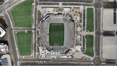 True Ortho of the completed stadium
"We really utilized Site Scan for the metrics. Coming from someone who is an artistic photographer and now I can get data from drone flights, that's the unsung hero of what Site Scan does."