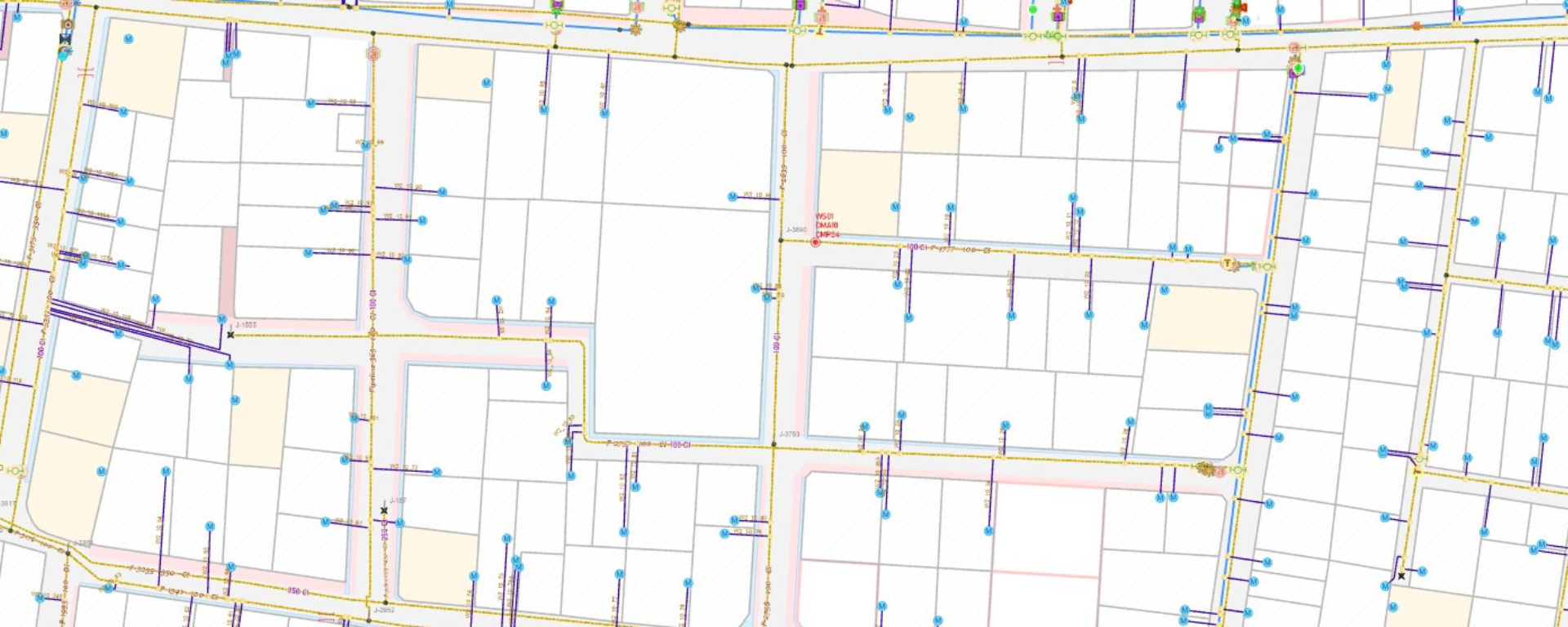
Suez uses Esri’s products (ArcGIS Pro + ArcGIS Enterprise) to generate a complete geo-tagged asset registry at the organization. Esri’s products are user-friendly and technically advanced. The impact of deploying GIS-based applications in our water and sewerage projects is truly commendable. The support and assistance provided by the Esri India team has been exceptional.
Suez Group has been active in the Indian water and wastewater market since 1978 and established an Indian subsidiary in 1986. Suez uses Esri products to enable comprehensive study and planning through GIS mapping, field surveys, and door-to-door surveys to analyze water demand patterns and improve water distribution. A recent development has been the successful integration of GIS-based maps in its Android-based O&M application. ML Infomap is the long-term partner of Esri India which has supported the execution of enterprise-level collaboration with Suez. ML Infomap expertise is in multiple technologies like GIS, Cloud Computing, Machine Learning, analytics, and visualization.
It creates IT/GIS solutions on the Esri platform. The intuitive user interface of ArcGIS Pro has significantly improved Suez’s workflow efficiency, allowing it to manage the field and backoffice data simultaneously. This has been achieved using ArcGIS Pro’s functionality that allows users to connect to the portal and editing in portal data directly. The seamless integration with ArcGIS Enterprise/Online has facilitated collaboration among team members and enhanced data sharing across departments.
ArcGIS Modules Used in the Projects
ArcGIS Desktop
ArcMap and ArcGIS Pro are instrumental in Suez’s data analysis, visualization, and map authoring tasks. The GIS system helps them to store all information about field activities (Topographic survey, customer survey, network survey, operational activities, etc.) and effectively perform tasks such as managing topography data, generation of contours, DEM, hydrology, etc.
ArcGIS Enterprise (Server/Portal)
Suez is also utilizing ArcGIS Enterprise (on-premises server) as the foundation of its GIS infrastructure that allows it to manage and share spatial data securely within the organization.
Web Applications
ArcGIS web app builder provides Suez with a user-friendly platform for creating custom web applications without requiring extensive programming knowledge. It offers pre-built widgets and templates to design interactive and responsive web apps that leverage the power of GIS data.
ArcGIS Dashboards
Suez uses ArcGIS Dashboards to create interactive dashboards that provide realtime insights into key performance indicators (KPIs), helping it to monitor and manage the water service status and operations effectively.
A suite of applications that are connected to the enterprise server and portal aids in field data collection, mapping, and asset management on mobile devices.
ArcGIS Field Map
This mobile app (map-based app) enables field data collection and update, streamlining the workflows for asset management, inspections, and maintenance activities related to the water service infrastructure.
ArcGIS Survey123 Connect
This app is designed for form-based data collection in the field using smartphones or tablets. It allows users to create customizable survey forms, collect data online /offline, and seamlessly integrate the collected data with GIS systems for analysis and visualization. It allows media attachments or geotagged media with respective features. These can be used for any form-based survey like customer survey, marking water leaks, trail pits location, etc. Overall, Survey123 is a versatile and user-friendly mobile application.
To download the PDF version of this article, click the button below.